top of page

Ten Days Online FDP on Advanced Remote Sensing and Machine Learning for
Environmental Sustainability
Session VII : Deep Learning for Airborne Surveillance Systems - Shri Dhipu TM , Scientist ‘E’, Centre for Airborne Systems – DRDO, Government of India.

Highlights of the Session - VII
-
Airborne Surveillance systems – concept and various vehicles used like drones, Unmanned Aided Vehicles(UAV), aerostats and big systems like airborne early warning and control systems were
explained. -
A clear-cut presentation of the Airborne Surveillance Framework and commonly used sensors- EO/IR, early warning radar were discussed.
-
Automatic Target Recognition(ATR) involving a whole gamut of technologies for detection, classification, Identification, tracking, Image segmentation, change detection, image fusion and the challenges incurred such as oblique angle of incidence, clutter, orthorectification were elaborated with appropriate pictures.
-
The concept of Deep learning was elucidated with forward & backward propagation and Least Mean Squares(LMS) algorithm.
-
Types of learning – Supervised, reinforcement and transfer learning; Common Neural Networks – Convolutional Neural Networks(CNN), Recurrent Neural Networks(RNN) and testing strategies were
discussed. -
The advancement of Deep Learning in Airborne Surveillance systems is facilitated by the hardwares and softwares such as CPU, GPU, programming languages- python, R, MATLAb, etc and ML/DL frameworks – Sci-kit learn, PyToch, etc. Also, the issues in Deep Learning was listed out.
-
The applications of Deep Learning based Airborne Surveillance systems like Air to ground surveillance, multimode maritime surveillance, border intelligence, surveillance and reconnaissance was explained.
-
And finally, few online dataset repositories which can be used to practice various Deep Learning based applications was showcased.
Session VIII : Role of Earth observation satellites for climate induced disasters - Dr Arjith Roy ,Head, Disaster Management Studies, Indian Institute of Remote Sensing - ISRO, Government of India.

Highlights of the Session - VIII
-
Natural disasters and the related factors such as hazard, exposure, risk and vulnerability were given insight. A brief introduction of Sendai framework with was given and its seven targets including reducing disaster mortality by 2030, reducing economic loss by 2030 were explained in detail.
-
Natural disasters in India like floods, cyclones, drought, extreme heat waves, landslides, wildfire and earthquakes were listed out and the causes of global climate change was described.
-
The effects of atmosphere and ocean warming such as reducing amount of snow and ice, sea level rise,increased concentration of greenhouse gases were narrated in brief.
-
The role of space technology in disaster management such as informed decision making, satellite based location service, satellite communication, etc. and the various steps like preparedness, disaster event,
relief, rehabilitation, reconstruction and mitigation were explained. -
Various Earth observation satellites like INSAT 3D/3DR, KALPANA, INSAT-3A (for weather & climate applications), OCEANSAT2, SARAL, ScatSat (for ocean applications), CARTOSAT-2 series, RISAT-2, CARTOSAT-1 (high resolution) and RESOURCESAT-2/2A, RISAT-2B (for land & water applications) were pointed out.
-
Natural disaster due to climate change, the extreme events such as increase in tropical cyclones due to increase in SST, increase in extreme precipitation events and space based observation for tracking
cyclones were explained with the case study of cyclone Amphan. -
Natural disaster due to climate change, flood frequency and its reasons like rise in sea level, increase in extreme and total precipitation, and change in patterns of snow were narrated briefly. Remote sensing
of flood is explained with the case study of Bihar floods, 2020.Some of its functions like satellite based precipitation from GPM-IMERG, microwave satellite data for all weather visibility and real time flood
inundation maps, etc. were pointed out. Early warning system for flood and the case study of kedarnath flood, 2013 was also briefed. -
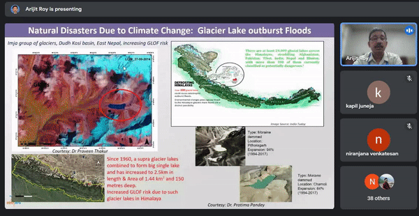
Natural disasters due to climate change like drought (meteorological, agricultural, and hydrological), glacier retreat and surge; glacier lake outburst floods were described with appropriate case studies.
-
Remote sensing and spatial modelling of heat waves, case study of forest fire detection using SENTINEL- 2 FCC (12, 11, 8) for Nainital, Uttarakhand, early warning system for forest fire were also explained in detail. The impact of forest fire emission on air quality, monitoring of particulate matter were given an insight.
-
Remote sensing of earthquake, Tsunami monitoring, early warning system for Tsunami, sea level rise and occurrence of large scale singular events due to climate change resulting in melting of polar ice
caps, decreasing the thermohaline condition in Northern ocean, the stop in great ocean conveyor belt were narrated in detail. National database for Emergency Management (NDEM) was explained and the
challenges, opportunities for student and researchers were pointed out.
Session IX : Geospatial Analysis for Human-Wildlife coexistence - Dr.Marguerite Madden , Director, Center for Geospatial Research, University of Georgia, USA.

Highlights of the Session - IX
-
The Objectives of elephant-human coexistence study such as Understanding elephant movements,linkages to development of local communal farming and drought towards mitigating human –elephant conflict, combining Geospatial technologies of remote sensing with Photogrammetry; Geovisualizations; Analysing spatial ; temporal movements and habitat condition to aid decision makers, etc. were discussed.
-
The effects of drought, which is the reason for human –wildlife conflict in Africa, severe drought in Zimbabwe, which killed more than 200 elephants and other wild animals were explained with the case study of African Elephant Movement Analysis at Kruger National Park, South Africa in the mid of 1990.
-
The topics such as how the African elephants use cognitive maps to navigate the core but not the periphery of their home ranges, landscape connectivity for elephant movement in Kruger National Park, integrating geospatial and ecological modelling, NPS Vegetation Inventory and Mapping Program were given insight.
-
The critical layers of various applications like land use, land cover, vegetation type, health,impervious surface, urban cove, water quality, ocean colour, geology ,etc. were listed out. The case studies of Kavango Zambezi Transfrontier Conservation Area (KAZA-TFCA), Elephant-Human conflict in Africa, crop raiding & attack on people were also narrated.
-
The need for successful interpretation like training & experience of interpreter, knowledge/collection of ground truth data, quality of images, nature of objects or phenomena were pointed out and the ways to develop the interpretation skills such as long hours of experience with photos, field visits, ground truthing, field observation, site visits, background in fields like geology, hydrology, geomorphology and so were explained.
-
The elements of image processing such as tone, texture, shape, size, etc. were explained. The mobile app namely SKY-Q for tracking bull elephant movements on cell phones, 3DIG-Research Trainings, Classifying LULC using digitized land using both ArcGIS and Google Earth Pro were discussed.
-
The case studies of Elephant Trajectory in dry and wet season were explained with the case study of South of Victoria falls and FYOS1001- First year Odyssey (40171) Human-Elephant conflict fall, 2021.
-
The use of GIS to access routes, repeated segments and corridors of animal movement, geospatial tool to assess movement, HRAM (Habitual Route Analysis Method), and 3D visualisation of GPS tracks were highlighted.
-
The method used to control crop raid such as chilli pepper mitigation- working with local families to protect croplands from elephant raiding was discussed.
-
The case study of large bull elephant broke through the 12 ft height in Victoria falls airport fence to eat wild melons in 2021 was also described.
-
Future works involving the use of deep learning and CNN for ID printing and analysis of elephant movement and behaviour and the student faculty community activities designed regarding the human-wildlife conflict were discussed.
bottom of page